- Home >
- Chapel Notre Dame des Vernettes to the Col de l'entreporte
Chapel Notre Dame des Vernettes to the Col de l'entreporte


Track information
Elevation (m)
:
740
Distance (km)
:
9.7
Daily duration (minutes)
:
330
 Departure/Arrival
 Point of interest
Circuit n° 1
Environments
- Environnements :
- Mountain location
In short
- Type d'itinéraire :
- Durée :
- 1 journée
- Levels of sporting experience :
- Level red – hard
- Pedestrian sports :
- Pedestrian sports
- Hiking itinerary
- Ouvertures complementaires :
- Subject to favorable weather
- Natures terrain :
- Stone
- Ground
Description
- Informations Pratiques :
- Itinéraire balisé
- Accessible tourism :
- Not accessible in a wheelchair
- Period :
- Autumn
- Summer
- Spring
- Sitra promotion typology :
- Not recommended in bad weather
- Open air
- Passages delicats :
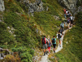
- Certains passages escarpés qui peuvent impressionner les personnes sujettes au vertige. De même il est prudent de ne pas s'y engager par temps incertain et en particulier pour la montée au col d'Entreporte. Sous l’épaule de l’Aiguille Grive (passages assez raides, parfois délicats).
- Some steep passages can impress people prone to vertigo. In the same way it is prudent not to engage yourselk in bad weather condition and especially to climb to the Col d'Entreporte. Under the shoulder of the Aiguille Grive (passages quite stiff, sometimes delicate).
- Einige steile Abschnitte, die Menschen anfällig für Schwindel beeindrucken können. Ebenso ist es ratsam, es nicht durch unsichere Wetter zu nehmen und vor allem für den Aufstieg auf den Entreporte. Unter der Schulter der Aiguille Grive (steile Passagen, manchmal empfindlich).
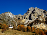
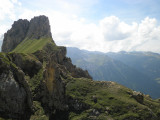
Diversité des paysages et ambiances pour cette randonnée : des forêts aux alpages en passant par les vertigineuses dolomites de l'Aiguille Rousse.
From the chapel ND des Vernettes take the path that goes horizontally on the left opposite the chapel towards the Entreporte pass. The path crosses the forest, forks to the right before the combe ski lift.
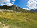
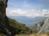
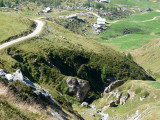
Stay on the edge of the plateau at the edge of the forest and follow the path upwards. This path crosses the Rey plateau under the shoulder of the Aiguille Grive (quite steep, sometimes tricky passages) then winds through a dolomitic landscape under the cliffs of ochre and grey cargneules of the Aiguille Rousse, before arriving at the Entreporte pass. In the mountain pasture, take the path towards the Col de la Chail. At the first intersection (after the Plan des Eaux chalet) turn right and go down the valley towards Les Rossets. The track continues in the direction of ND des Vernettes. Leave the track at the first bend in the forest of Carro Blanc to take a small steep path that leads to the chapel.
Stay on the edge of the plateau at the edge of the forest and follow the path upwards. This path crosses the Rey plateau under the shoulder of the Aiguille Grive (quite steep, sometimes tricky passages) then winds through a dolomitic landscape under the cliffs of ochre and grey cargneules of the Aiguille Rousse, before arriving at the Entreporte pass. In the mountain pasture, take the path towards the Col de la Chail. At the first intersection (after the Plan des Eaux chalet) turn right and go down the valley towards Les Rossets. The track continues in the direction of ND des Vernettes. Leave the track at the first bend in the forest of Carro Blanc to take a small steep path that leads to the chapel.
Photos
Photos


We also suggest...
